Gore Road Transportation Improvements
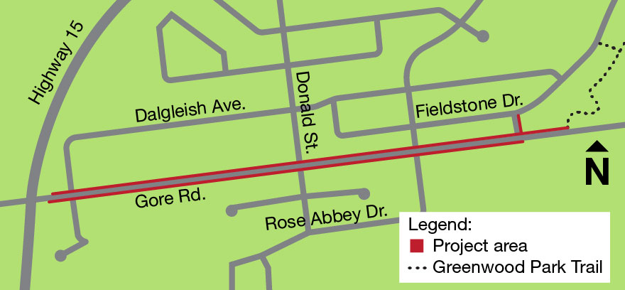
New and improved pedestrian, cyclist, and active transportation infrastructure is planned for Gore Road between Highway 15 and the Greenwood Park Trail. Once completed, these improvements will connect the Greenwood Park neighbourhood to the City's larger active transportation network via the Waaban Crossing. Design work is ongoing in 2026 with construction to start in late 2026.
Planned improvements
- Roadway improvements, including roadway alignment improvements and new asphalt
- New Multi-Use Path (MUP) on the north side of Gore Road to make it easier and safer for pedestrians and cyclists to connect to the Waaban Crossing and Greenwood Park Trail network.
- Extension of the existing sidewalk on the south side of Gore Road from Rose Abbey Drive to the Greenwood Park Trail.
- Improved lighting for the roadway and MUP.
- Pedestrian and bike crossing improvements.
- Drainage improvements throughout the corridor including culvert replacements.
- Turtle Fencing and Turtle Crossing at Butternut Creek.
Construction Impacts
- Access: During construction, there may be lane reductions and occasional localized closures. Local access to the Greenwood Park neighbourhood will be maintained. Advanced signage will be in place to notify of upcoming impacts and detours.
Stay informed
Project updates, including more details on construction impacts, will be shared on this page and with project followers. Use the follow project feature on this page to subscribe to receive updates in your inbox.
New and improved pedestrian, cyclist, and active transportation infrastructure is planned for Gore Road between Highway 15 and the Greenwood Park Trail. Once completed, these improvements will connect the Greenwood Park neighbourhood to the City's larger active transportation network via the Waaban Crossing. Design work is ongoing in 2026 with construction to start in late 2026.
Planned improvements
- Roadway improvements, including roadway alignment improvements and new asphalt
- New Multi-Use Path (MUP) on the north side of Gore Road to make it easier and safer for pedestrians and cyclists to connect to the Waaban Crossing and Greenwood Park Trail network.
- Extension of the existing sidewalk on the south side of Gore Road from Rose Abbey Drive to the Greenwood Park Trail.
- Improved lighting for the roadway and MUP.
- Pedestrian and bike crossing improvements.
- Drainage improvements throughout the corridor including culvert replacements.
- Turtle Fencing and Turtle Crossing at Butternut Creek.
Construction Impacts
- Access: During construction, there may be lane reductions and occasional localized closures. Local access to the Greenwood Park neighbourhood will be maintained. Advanced signage will be in place to notify of upcoming impacts and detours.
Stay informed
Project updates, including more details on construction impacts, will be shared on this page and with project followers. Use the follow project feature on this page to subscribe to receive updates in your inbox.
-
What We Learned: Gore Road Rest Areas Survey
Why we engaged
The purpose of this engagement is to seek input on where rest areas should be located along the new multi-use pathway on Gore Road. Feedback received will help identify preferred rest area locations and provide valuable input on the overall pathway project. This input will help refine design details while balancing safety, accessibility, and technical requirements.
How we engaged
Images of the project layout, including proposed rest areas, were published on the Get Involved Kingston project page. Users were invited to review the map images and project renderings and submit comments in an online survey from July 7 until July 28. Residents also had the option to submit feedback via phone or email. Feedback submitted via alternate methods was submitted to the survey on Get Involved Kingston.
The opportunity for input was communicated by a news release, direct emails to project followers and Get Involved Kingston users, and social media posts on the City’s channels. The district councillor also helped spread the word in neighbourhood Facebook groups. Additionally, a mailout was sent to nearby neighbours (60m radius from project limits) and posters were put up at nearby locations including the Kingston East Community Centre and the Pittsburgh library branch.
Who we heard from
- 92 participants completed the survey (16 of them submitted feedback via email and phone)
- 1,214 visits to project page to learn more
- 14 new registrations on Get Involved Kingston
- Locations of respondents (Question 1):
- 64% live in the neighbourhood immediately adjacent to Gore Road
- 77% live in Pittsburgh district
What we learned
Feedback on the proposed locations is generally positive, with many comments expressing clear support for the rest stops and broader transportation improvements. A small segment of comments were neutral with no strong opinion but some questions or conditional support. Only a few comments were in opposition to the proposed rest stops and locations.
Overall, there was widespread recognition that rest stops could improve comfort, accessibility and overall user experience for pedestrians and cyclists. Many viewed them as important for seniors, people with mobility challenges, families with strollers and those travelling longer distances.
The following table is a summary of feedback themes identified and responses to each theme.
Rank Feedback Theme Mentions What We Heard (Key Specifics & Community Context) Response / Comment 1
Pathway & Cycling Network Support
23
Broad community enthusiasm for separated active transportation, extending bike connections, improved safety over existing narrow shoulders, and closing network gaps to Hwy 15 and Waaban Crossing.
Support for improved active transportation connections is consistent with Council’s strategic priority of fostering an active and connected community.
2
Approval of Proposed Rest Area Concept
13
General agreement that the concept, spacing, and distribution of rest areas along the corridor are logical, well-placed, and much-needed for active transportation users.
Positive feedback on the proposed rest area concept validates planned improvements along the corridor.
3
Rest Stop Micro-Siting Adjustments
10
Specific location modifications requested: shifting stops directly to trailheads (Greenwood Park / Butternut Creek) to accommodate strollers and bikes, setting benches further east away from Hwy 15, adding south-side seating, and utilizing quieter park nodes.
Based on feedback, rest stops were added along the sidewalk on the south side of the corridor, and minor adjustments were made to some proposed rest stop locations.
4
Shade, Tree Canopy & Landscaping
8
North-side seating is exposed to full summer sun; residents strongly requested planting native shade trees near benches, as well as incorporating edible landscaping, pollinator strips, and greenery along the boulevard.
Rest area locations were adjusted to take better advantage of shade from existing trees, with new tree planting proposed where space allows along the corridor.
5
Gore Road Pavement Condition
5
Gore Road is severely deteriorated with potholes, rutting, and hazardous shoulders; strong community expectation that the road will be fully repaved from Dalgleish to Fieldstone alongside path works.
Asphalt and pothole repairs have been completed in the most deteriorated areas to extend the life of the road until planned road work begins in 2027.
6
Hwy 15 / Gore Rd Intersection Operations
5
Safety concerns at Highway 15: requests for bi-directional cycle crossrides (specifically the east crossing) to connect with the north-side multi-use pathway, addressing blind left turns, and improving signal/crosswalk visibility.
Staff will not be altering the Hwy 15 intersection; details are addressed in FAQs.
7
Transit Integration & Bus Stops
4
Ensure rest areas at McLean Park are physically separated from bus stops so Kingston Transit operators do not stop needlessly for trail users; requests for improved shelters at transit stops.
Bus stops are separate from the multi-use pathway rest areas.
8
Commercial Plaza Access & Congestion
3
Rush-hour congestion and turning conflicts at the shopping plaza entrance east of the fire hall; requests for a dedicated right-turn lane and safe mid-block pedestrian crossings between opposite bus stops.
The City has determined a turn lane at the shopping plaza is not warranted based on traffic counts.
9
Amenities & Design Enhancements
3
Inclusion of waste and recycling receptacles at rest pads, interest in public washroom facilities, and suggestions for creative features (permeable pavers, green roofs, public mosaic art).
The installation and placement of waste receptacles along the corridor have been referred to the Public Works department for consideration.
10
Traffic Calming & Alternative Controls
2
Inquiries regarding roundabouts/traffic circles in lieu of traditional stop signs to improve traffic flow, and raised crosswalks/intersections to naturally calm vehicle speeds
Questions about roundabouts and raised crossings have been addressed in the project's FAQs.
Next stepsResults from this survey have been shared with the project team for review, and feedback received above was incorporated into the overall design for corridor improvements. Construction is expected to begin in December 2026. An updated project timeline is listed below:
Fall 2026: Detailed Design Phase for corridor improvements is completed
December 2026: Construction begins with the Butternut Creek Cross Culvert
Winter 2026- 2027: Winter seasonal shutdown
Spring 2027: Construction resumes
End of 2027: Construction is planned to be completed by the end of 2027
-
Project Update – Gore Road Rest Areas Survey
In July 2026, we conducted an engagement on Gore Road rest areas. Community members were invited to review the map layout and project renderings, and asked to submit comments in an online survey.
Feedback received will help identify preferred rest area locations and provide valuable input on the overall pathway project.
- 92 participants completed the survey
- 16 submitted feedback via email and phone
- 1,214 visits to the project page to learn more
- 14 new registrations on Get Involved Kingston
- Locations of respondents (Question 1):
- 64% live in the neighbourhood immediately adjacent to Gore Road
- 77% live in the Pittsburgh district
The project team is currently reviewing all comments. Community input will help refine design details while balancing safety, accessibility, and technical requirements.
Responses to common questions have been added to the FAQs on the project page. A full summary report will be published on this once the project team has completed their review of the feedback.
-
Proposed project design and renderings
Review the following images of the project design, including proposed rest stops (below in red).
To view the full map layout in PDF format, click here.
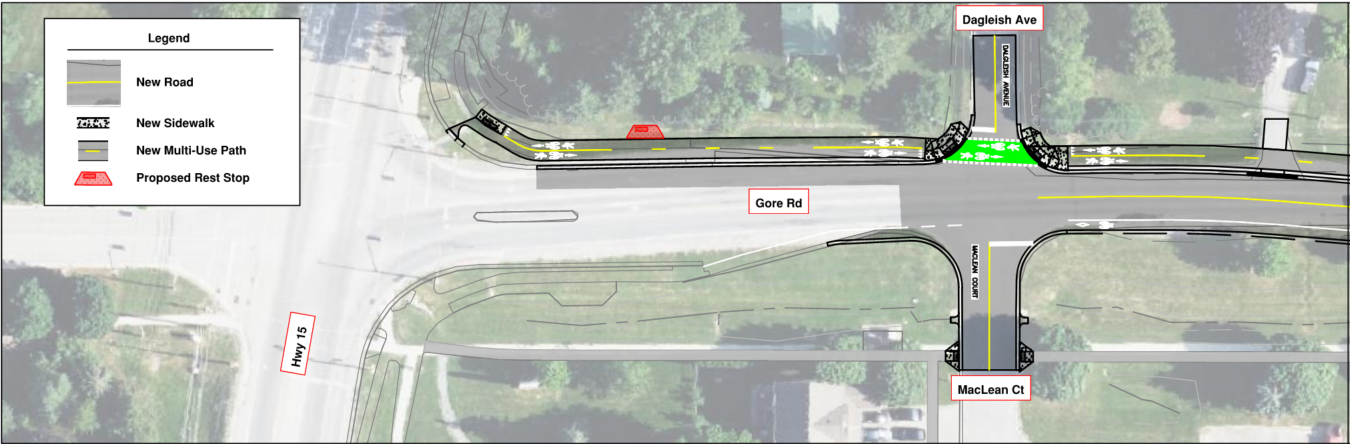 Highway 15 to Firehall entrance
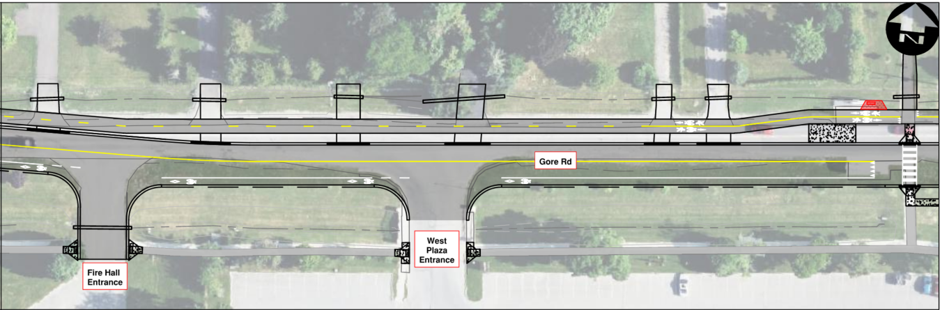 Firehall entrance to Maclean Park
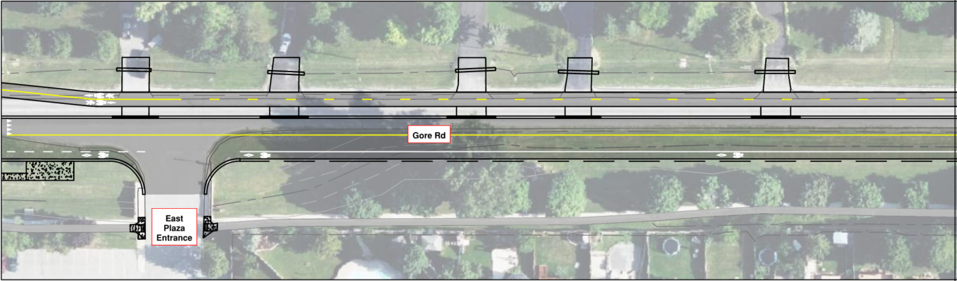 Maclean Park towards Donald Steet/Grenadier Ave
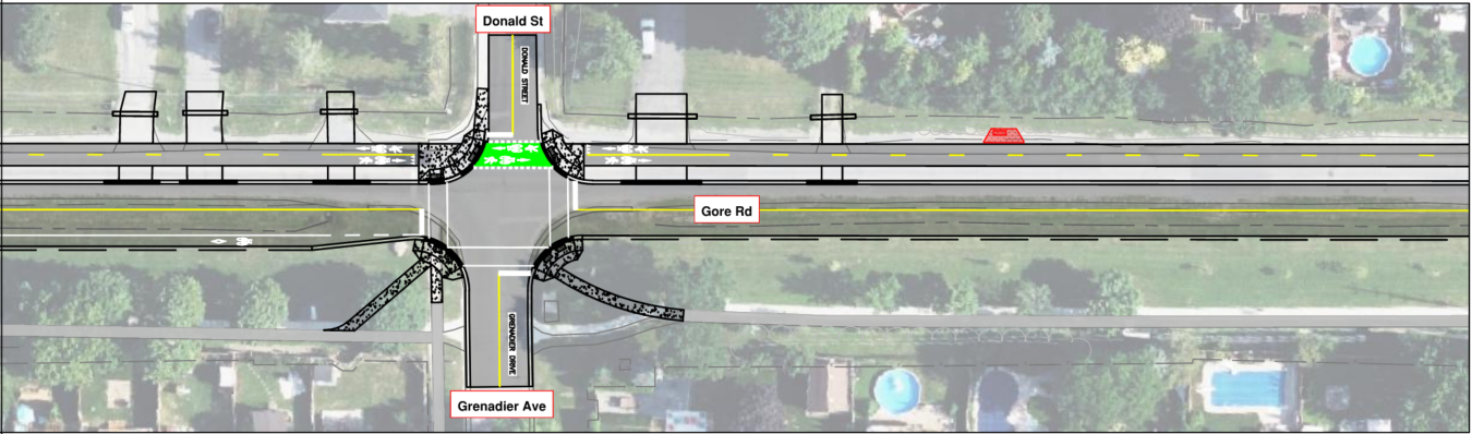 Donald Steet/Grenadier Ave towards Rose Abbey Drive
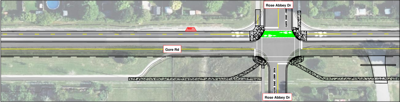 Rose Abbey Drive towards Fieldstone Drive
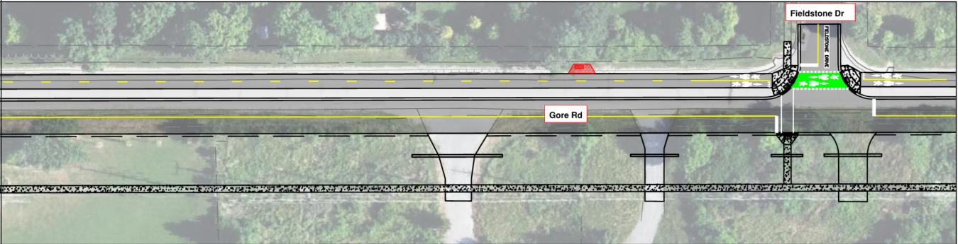 Rose Abbey Drive towards Fieldstone Drive (continued)
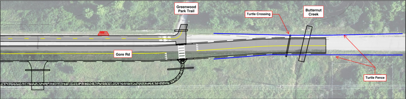 Fieldstone Drive to Butternut Creek
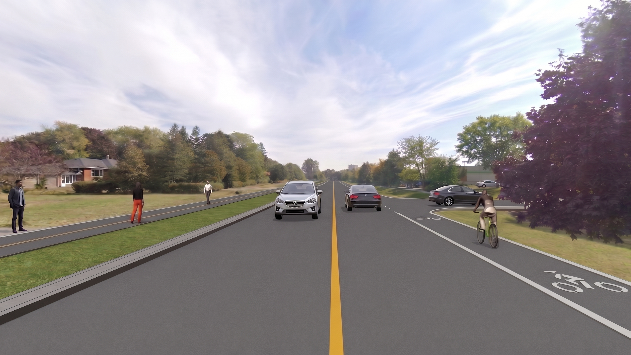 Gore Road rendering at Plaza entrance
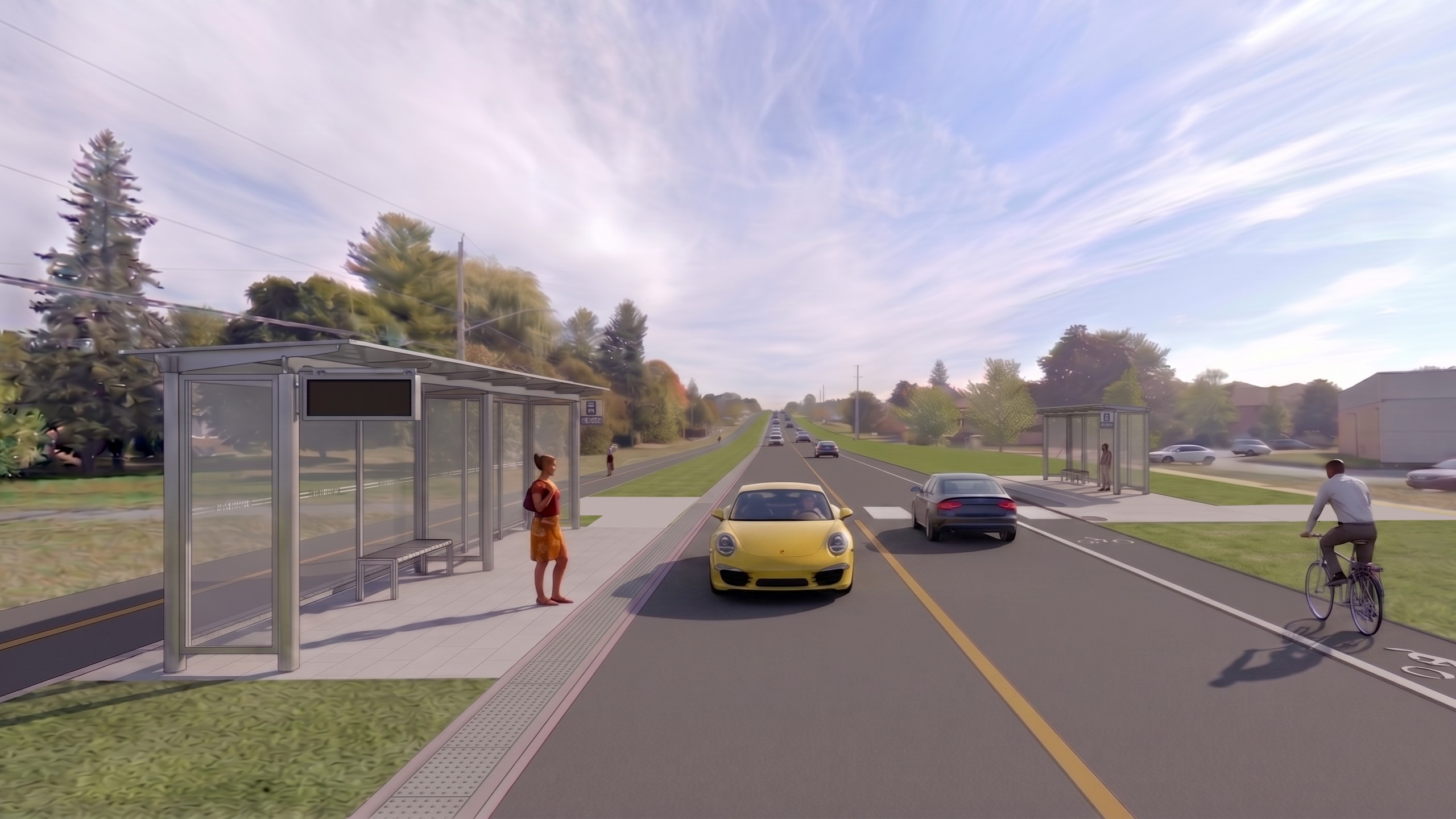 Gore Road rendering at Maclean Park
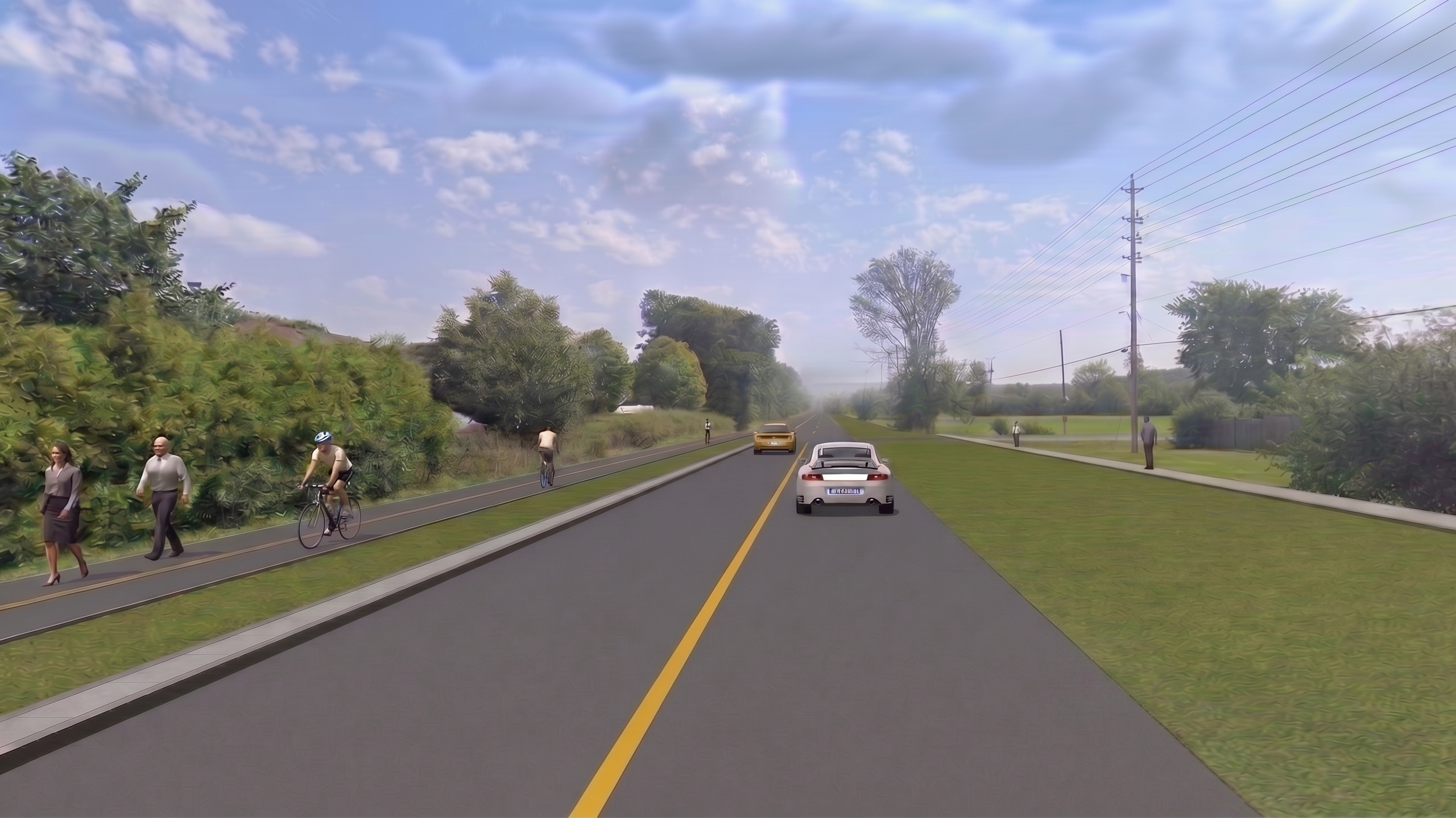 Gore Road rendering Fieldstone Drive and Rose Abbey Drive
Review the following images of the project design, including proposed rest stops (below in red).
To view the full map layout in PDF format, click here.
Highway 15 to Firehall entranceFirehall entrance to Maclean ParkMaclean Park towards Donald Steet/Grenadier AveDonald Steet/Grenadier Ave towards Rose Abbey DriveRose Abbey Drive towards Fieldstone DriveRose Abbey Drive towards Fieldstone Drive (continued)Fieldstone Drive to Butternut CreekGore Road rendering at Plaza entranceGore Road rendering at Maclean ParkGore Road rendering Fieldstone Drive and Rose Abbey Drive
-
Fall 2026
Gore Road Transportation Improvements is currently at this stageDetailed Design Phase for corridor improvements is completed
-
December 2026
this is an upcoming stage for Gore Road Transportation ImprovementsConstruction begins with the Butternut Creek Cross Culvert
-
Winter 2026- 2027
this is an upcoming stage for Gore Road Transportation ImprovementsWinter seasonal shutdown
-
Spring 2027
this is an upcoming stage for Gore Road Transportation ImprovementsConstruction resumes
-
End of 2027
this is an upcoming stage for Gore Road Transportation ImprovementsConstruction is planned to be completed by the end of 2027
-
July 07 → July 28 2026


All information received will be compiled and considered by staff for use under the purposes of this site. Information will be collected and used in accordance with the Municipal Freedom of Information and Protection of Privacy Act and other relevant privacy legislation. All comments made on this site are available to the public and may form part of public records.
We use the IAP2 Spectrum of Public Participation to let you know how feedback on a project will be used. Here's how we are seeking and using your feedback on this project.
Inform: We will keep you informed by providing balanced and objective information to assist you in understanding the problem, alternatives, opportunities and/or solutions.
Consult: We will keep you informed, listen to and acknowledge concerns and aspirations, and provide feedback on how public input influenced the decision.
- Why is the City completing this work?
- Did the City consider roundabouts as part of the Gore Rd project?
- Can roundabouts fit in the existing Right of Way?
- When would the traffic volume meet the need for a roundabout?
- Will there be a crosswalk between the two bus stops on Gore Road near the shopping plaza?
- Are there any changes being considered for the Hwy 15 / Gore Rd intersection?
- Could the shouldered bike lane be continued until Fieldstone?
- What will the rest stops look like?
- Do the rest stops have lighting?
- Why is the multi-use path being built on the north side of Gore Rd?
- Will e-bikes be allowed on the MUP?